


The greatest impact of GIS used by DHS, FEMA, and local Agencies often happens in…
By Nate Smith
Starting at: $397
It’s a challenging path but there is a recipe of modern entrepreneurship to increase your…
By Andres Abyeta
Starting at: $397
The US Forest Service covers about 300,000 square miles and needs to be informed by…
By Bo Wilmer
Starting at: $397
The greatest impact of GIS used by DHS, FEMA, and local Agencies often happens in…
By Nate Smith
Starting at: $397
It’s a challenging path but there is a recipe of modern entrepreneurship to increase your…
By Andres Abeyta
Starting at: $397
The US Forest Service covers about 300,000 square miles and needs to be informed by…
By Bo Wilmer
Starting at: $397
Remotely sensed data has a new acquisition source. Many local dynamic projects now use UAVs.
By Frank McDermott
Starting at: $397
Use a crowdsource approach to add graffiti, signs, or potholes in an enterprise work order…
By Shital Dhakal
Starting at: $397
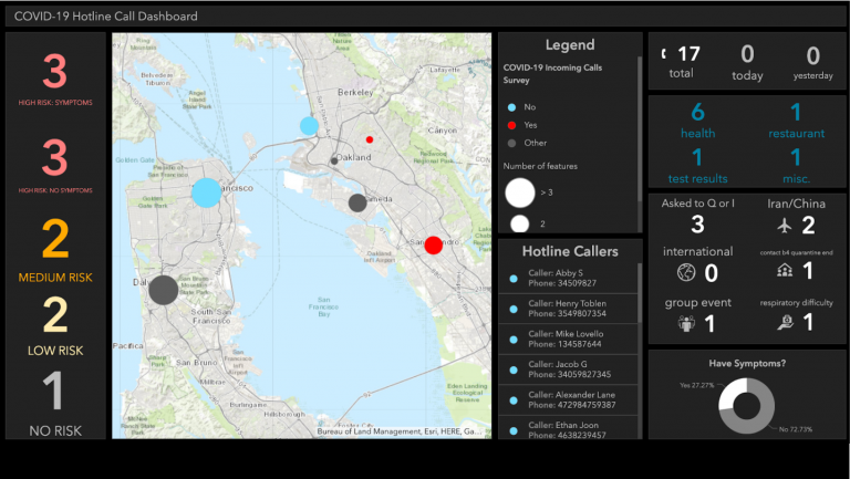
Everyone wants to see the cumulative view of a GIS dashboard. Learn the entire process within…
By Andrea Befus
Starting at: $397
Remotely sensed data has a new acquisition source. Many local dynamic projects now use UAVs.
By Frank McDermott
Starting at: $397
Use a crowdsource approach to add graffiti, signs, or potholes in an enterprise work order…
By Shital Dhakal
Starting at: $397
Everyone wants to see the cumulative view of a GIS dashboard. Learn the entire process within…
By Andrea Befus
Starting at: $397
A course for managers/architects with templates to inform strategic plans and presentations…
By Nathan Heazlewood
Starting at: $397
Build a data science model to analyze food insecurities in United Stated and visualize the…
By Melissa Anthony
Starting at: $397
Use this template to successfully manage a GIS within the landscape of changing requirements…
By Nicole Peace
Starting at: $397
Every city maintains a large data set and web map servers, and Amazon is a popular hosting choice.
By Imtiaz Syed
Starting at: $397
Configure an AWS server hosting Esri map services containing imagery and wildfire data…
By Aaron Kochman
Starting at: $397
Automatically extract, transform, and load (ETL) data into AWS data repository for AEC…
By Kevin Weller
Starting at: $397
Centralization of data, users, and application in a cloud Geoportal is the powerful trend…
By Karen Volarich
Starting at: $397
Sustainable development projects compete for funding and must results. You will use GIS to…
By Valrie Grant
Starting at: $397
It’s time to learn ArcGIS Pro in the ral context of natural resources management.
By Anfres Abyeta
Starting at: $397
Centralization of data, users, and application in a cloud Geoportal is the powerful trend…
By Karen Volarich
Starting at: $397
Sustainable development projects compete for funding and must results. You will use GIS to…
By Valrie Grant
Starting at: $397
It’s time to learn ArcGIS Pro in the ral context of natural resources management.
By Andres Abeyta
Starting at: $397
Add a location based service to restaurant locator Android app.
By Aaron Michel
Starting at: $397
Evaluate and secure data vulnerabilities in a geospatial cybersecurity program.
By Clarence Jackson
Starting at: $397
Add a location based service to restaurant locator Android app.
By Aaron Michel
Starting at: $397
Evaluate and secure data vulnerabilities in a geospatial cybersecurity program.
By Clarence Jackson
Starting at: $397
The world’s only GIS certificate program where industry experts teach you what they do to help you win a job in GIS.
Enter your email below we’ll send you a note when its posted along with a $20 coupon code.
Thanks and we can’t wait to connect with you!
Enter your email below we’ll send you a note when its posted along with a $20 coupon code.
Thanks and we can’t wait to connect with you!
Enter your email below we’ll send you a note when its posted along with a $20 coupon code.
Thanks and we can’t wait to connect with you!
| Cookie | Duration | Description |
|---|---|---|
| cookielawinfo-checkbox-analytics | 11 months | This cookie is set by GDPR Cookie Consent plugin. The cookie is used to store the user consent for the cookies in the category "Analytics". |
| cookielawinfo-checkbox-functional | 11 months | The cookie is set by GDPR cookie consent to record the user consent for the cookies in the category "Functional". |
| cookielawinfo-checkbox-necessary | 11 months | This cookie is set by GDPR Cookie Consent plugin. The cookies is used to store the user consent for the cookies in the category "Necessary". |
| cookielawinfo-checkbox-others | 11 months | This cookie is set by GDPR Cookie Consent plugin. The cookie is used to store the user consent for the cookies in the category "Other. |
| cookielawinfo-checkbox-performance | 11 months | This cookie is set by GDPR Cookie Consent plugin. The cookie is used to store the user consent for the cookies in the category "Performance". |
| viewed_cookie_policy | 11 months | The cookie is set by the GDPR Cookie Consent plugin and is used to store whether or not user has consented to the use of cookies. It does not store any personal data. |