Get Your Online Degree in GIS Programs: Top 5 Colleges For GIS Certificate
What is GIS
If you want to figure out new business locations, determine locational trends for crimes, or plan the viability of a solar farm, you’ll definitely be using GIS. GIS stands for Geographical Information System, a computer-based tool to store, visualize, analyze, and interpret geographical data. This system matches locations with events happening. Nearly all of us have been a user of GIS without even noticing. For example, when you are checking the location of your Doordash delivery, GIS is in place. Being a fast developing industry, GIS Certificate provides a wide variety of careers to anyone who is interested in using technology for environmental concerns. Accordingly, getting a degree in GIS is probably the fastest way to enter the industry. This article will explore career opportunities in the GIS field and multiple approaches to getting GIS degrees.
Salaries for GIS
GIS is a diverse field with abundant job opportunities. Companies that are developing offshoot products need skilled people with a GIS degree, creating thousands of job opportunities. Salaries in the GIS field vary from $40,000 to $155,000+. At an entry level, for example, technicians, draftsmen and analysts have an average salary of $40,000 to $60,000. This refers to those who handle basic roles like data editing and metadata writing. When we climb up the salary ladder, higher payments are offered to specialists in the field. Higher level skills in GIS will include Python programming, database administration, and GIS web development. For instance, analysts that specialized in LiDAR, sensors that collect elevation information, earned an average salary of $71,000.
How to learn GIS
These days there are multiple ways to get a GIS degree, both in colleges and online courses. Firstly, most colleges teach GIS within the Geography Department. Therefore, you could get a Geography degree which will include few GIS courses. Another option is to combine your existing degree in any field with a GIS certificate from your local college. However, as a fast developing industry, materials taught in classrooms might be too basic, too general, or using out of date software. In this case, online resources are useful.
In addition to learning, pursue industry connections. Social media sites like Linkedin and Facebook offer opportunities to speak directly with people who are already in the industry. Get their first-hand experience through direct messaging!
Also, Esri, the developer of ArcGIS, holds conferences each year which offers great networking opportunities and resources for people interested in GIS fields. The conference is held every summer in San Diego, CA while representing the largest gathering of GIS users in the world. Sign up for the Esri UC and you’ll have lots of fun. However, these resources may not give up-to-date information or systematic training for someone who is interested in GIS. But there are alternatives! You can get a GIS degree from home by completing certificate programs online. It is both time-saving and money-saving. Rather than spending 2 years in a master program, you can get your degree online within 6 months and enter the industry with competitive skills.
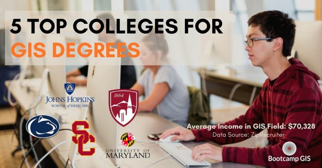
Best GIS Certificate Programs
There are over 200 colleges and universities that offer a GIS program. A list of all colleges was conducted by GISGeography. Here are some of the best GIS programs across the country.
| Item | Program Name | Duration | Cost |
| 1 | University of Denver This program focuses on the ability to plan, launch and execute GIS programs using various digital methods. |
12 months | $17K |
| 2 | Pennsylvania State University This program aims at professionals in the industry, helping them to be more specialized with a customized curriculum. |
30 months |
$36K |
| 3 | University of Southern California This program focuses mostly on data science skills and information engineering. |
2 years |
$65K |
| 4 | Johns Hopkins University This program gives students valuable experience in the GIS industry while learning up-to-date applications of digital transformation. |
9-12 months | $22K |
| 5 | University of Maryland This program aims to provide the most up-to-date education on geospatial technology, theory and applications. |
15 months | $15K |
Online GIS Certificates: Get Your Advisement Session Today!
Afraid of the high tuition? Cannot move to a new city that offers a program? Get your GIS certification online at Bootcamp GIS within 6 months! Bootcamp GIS offers project based online GIS courses with prices as low as $397. You can learn about industry, data analysis, and GIS web development through this online program. Book your free advisory session today to hear about 5 key GIS industry trends!