
GIS Analyst Salaries in a Trending Industry
GIS Analyst
In today’s society, GIS systems are ubiquitous and people use them almost every day without realizing it. So what is GIS? Simply put, it is a computer system for creating, managing, analyzing, and entering geographic data that contains location and descriptive attributes about that location. An example is Zillow that locates a parcel and shows attributes about ownership zoning, and home value. To become a GIS Analyst, it requires courses, certificates, or degrees in the study of geography and IT. Their main responsibilities include analyzing spatial data through mapping software and using the data to create digital maps and live mapping applications. It’s an interesting and diverse job because in conjunction with technical skills, the GIS Analyst will have education and experience in vertical disciplines such as urban planning, environmental science, or engineering.
 By GISGeography, May 29, 2022
 By
By Average salary
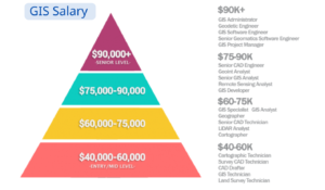
Because of the proliferation of data, GIS is a high growth tech job. There are a variety of technologies that you will use such as GIS software, UAVs, cloud servers, and Python scripting. The more skills and experience you have, the more salary you will receive (GIS Analyst salaries in the US range from $40K to $112K). According to the survey, there are three different salary levels, the first is the entry-level salary of $40K-$60K, the Mid-range salary between $60K-$80K, and the High-end salary is over $80K. The average annual GIS salary in the United States is $72.5K. One of the top 10 cities for high paying GIS jobs is San Mateo which can reach $92K per year.
Remote job
Due to the pandemic, many employees have been asked to work remotely or from home. Because of internet and FTP access, GIS Analysts can work from anywhere to complete data development and analysis tasks. Currently, there are about $29,000 GIS Analysts employed in the United States, and more than half of them choose to work remotely because not only do they enjoy a comfortable environment, but it also facilitates internal management and access to happier employees. For remote work salaries, as of June 2022, the average weekly salary for most remote GIS Analysts in the United States is $1689, while the hourly rate is $42 per hour, and the annual salary is nearly $10,000 more than the average regular job.
How to find GIS Training & jobs near me
The difference in cost of living drives a range of salaries in different states. For example, Delaware in the East, with an average salary of $82,379, and New York in second place, with an average salary of $77,060, Oregon on the West Coast, with an average salary of $77,577, and California, with an average salary of $76,539. Search online through sites such as Zip recruiter or Indeed, where you can set up a personal account and then search for GIS Analyst keywords according to your locational preferences. Through online search, you can get basic information, job content and job salary of the recruiting company. Online job platforms have become very sophisticated and specific and you should use this to your advantage.
Online GIS Courses and education
So what skills do you need and how do you acquire them? There are lots of university programs that offer GIS courses. You will find courses that are standard and somewhat general information such as Intro to Remote Sensing or Intro to Cartography. You can get more specific with learning GIS software through Esri or QGIS. If you want a real world focus by instructors working in industry, look at the Bootcamp GIS course catalog which teaches project-based courses online. This is a career that is learnable in a short period of time. You’ll get plenty of inspiration if you just talk to any of us in the profession that can tell you what we do and why we like the work.