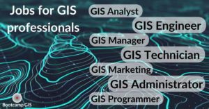
Jobs for GIS Certificate professionals
GIS is a growing industry. The value of the GIS market will reach $24.6M by 2030. If you are looking at transitioning into tech, this could be a promising career for you. There are several reasons to think about pursuing a job in the rising GIS industry? Let’s talk about the professional roles within the GIS field to help you to determine if they are the jobs that you are looking for.
Not only can you earn a living, but you will also be doing something meaningful to contribute to society. For instance, GIS maps help emergency services to save lives. Also, GIS helps the Centers for Disease Control and Prevention (CDC) to study the topics of finding the locations of the diseases, the relationship between diseases and the circumstance, and the rates of diseases. There are plenty of different positions and roles in the GIS industry and you can find GIS jobs in any industry. We are positive that there are positions and projects for you to reach your full potential.
GIS Technician
This is the entry level role in the industry. GIS technicians work on data creation and design maps for government agencies and companies. Giving support to a GIS program is your responsibility. This means working with experienced developers, IT staff, and field professionals to help populate a GIS database.
The average salary that a GIS technician earns in a year is $45,005 in the US. Local cities and commercial geospatial software companies will hire GIS technicians. GIS Techs may or may not be required to have a degree. But they may be working on a bachelor’s degree in computer science, geography, or engineering. You will just need to show that you are good at problem-solving, analyzing, and have some knowledge in mapping.
GIS Analyst
Cities hire GIS analysts to collect and update geographic data, make maps, and perform higher level modeling and analysis. GIS analysts use the data to track different aspects of urban planning, engineering, and environmental protection. There are plenty of job opportunities for you if you want to be a GIS analyst. Local, state, and federal governments and non-profit and private companies also count on GIS analysts to do planning and build up data to inform their planning decisions.
The average salary of a GIS analyst is $63K per year in the US. Local cities and companies like Spectrum and Metropolitan Transportation Authority hire GIS analysts. This role suits you if you have the ability to handle complicated databases, and measurement analysis. You may need a bachelor’s or master’s degree in geography, survey engineering, or computer science. Some GIS certificate programs can help you up-skill to be competitive for these jobs.
GIS Engineer
GIS engineers may take part in jobs from different departments like transportation, emergency services, and urban planning. They usually survey and evaluate the possibility of the needs of their stakeholders. Then they develop workflows and IT architecture that make up the GIS system.
The average salary of a GIS engineer is $82K per year. Private companies like Esri employ GIS engineers. You will need more practical experience, gain GIS certifications, and should think about getting an advanced degree or certificate to be a GIS engineer. There are some important skills such as cloud services or database administration that can help you become a GIS engineer.

GIS Programmer
Using programming languages like Python to write routines that automate data to support geographic information systems is the job of GIS programmers. They develop web applications that are served to large audiences as in the case of Zillow maps or the Johns Hopkins COVID dashboard.
The average salary that a GIS programmer earns in a year is $87k in the US. The cities of Providence and Raleigh have the most GIS programmer job openings. You will want to learn different coding languages like Python, HTML, CSS, C# and have a bachelor’s degree in geography, GIS, engineering, or other related domains. Many of these skills can be learned with online projects. Then you can apply them to develop web mapping applications in any industry such as health, sustainability, and emergency services.
GIS Administrator
Maintaining a dependable live GIS for your organization or the public is a responsibility of GIS administrators. You will need to install and set up software, configure servers, manage the database, and answer and reply to the requests for mapping and information data. You may have to be a part of the team of disaster operations when there are emergencies.
The average salary a GIS administrator earns in a year is $89K in the US. Some public companies like Cable One and state & regional agencies like any US county will employ GIS administrators. You need to have a bachelor’s or master’s degree in geography, GIS, or IT. Administrators often use enterprise software produced by Esri.
GIS Manager
GIS managers need to make sure the GIS program runs efficiently to support the organization’s stakeholders and clients. They mentor and train the team and their staff, and take part in the commercial side of the GIS industry to network and collaborate with other professionals at conferences and workshops.
The average salary that a GIS manager earns in a year is $75K in the US. The industry of energy & utilities and plenty of public and private companies will hire GIS managers. A manager usually gets promoted from within the GIS department, but a bachelor’s degree with a GIS certificate or an advanced degree and around 4 years of working experience in business management is common.
GIS Marketing
A GIS marketing representative needs to have rich knowledge of Search Engine Optimization (SEO). It is a useful tool while writing content and understanding the rates of keywords that people use most on Google. You know about government proposal platforms like GovWin. It is a platform that helps government contractors find released proposals to win business. A GIS marketing analyst or coordinator earns $65K per year on average. And, most companies such as Esri need GIS marketers.
Events and conference exhibits like Esri UC, Esri Fed UC, and JETC are some of the largest GIS conferences for the decision-makers of the industry and government to network and collaborate. For example, GeoWERX which assembled companies from the Society of American Military Engineers (SAME) to discuss the geospatial solution and earn GIS certificates was done at a JETC conference exhibit.
Conclusion
Now you know how diverse and attractive the GIS jobs are. Although some of the positions need plenty of GIS skills, you can learn most of these skills online. Bootcamp GIS is the top online learning platform that offers project based GIS courses with a flexible start time, affordable price, and helps you to get a certificate in 6 months. Shop around and you can determine if you need a course, a certificate, or an entire degree.