Top reviews from Script A Python Data Science Model To Map Food Insecurity
Script a Python Data Science Model to Map Food Insecurity
Due to proliferating digital data, one of the fastest growing industries is data science. In this class you will create a Python data science model within the sphere of COVID-19 impacts. The products will be data science correlation tables, graphic plots, QGIS maps, and a published dashboard. You’ll be equipped with skills that are marketable with almost any agency trying to turn data into knowledge.
567 students enrolled
KEY PARTNERS:
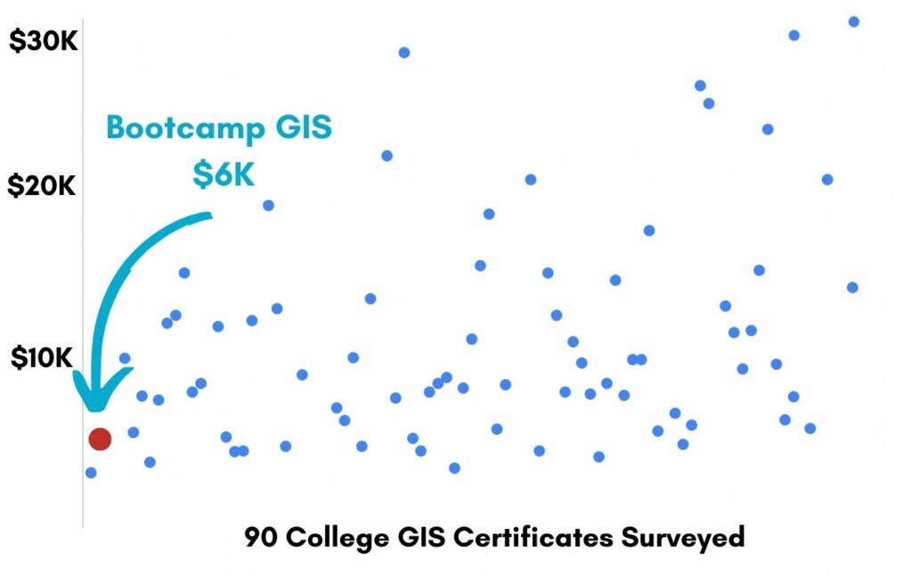
You’ve worked hard, but want better career results. Our program helps when…
Script a Python Data Science Model to
Map Food Insecurity
Join this class and get access to 10 modules that give you the ability to build a data science model and visualize the results in GIS.
The Sea of Big Data
(aka Harvesting the right data needed to analyze the problem)
The Rag and Mop
(aka Scrub your data to clean it up)
Spot the Indicators
(aka Figure out the variables that your problem is sensitive to)
Coding Intelligence
(aka Write a data science model)
Did it Work?
(aka Interpret your resulting numbers)
Swami says…
(aka The model makes predictions on other datasets)
Matchmaking
(aka Where the data science model gets hooked up to GIS)
Where’s the Problem
(aka Visualize the numbers and locations)
Holistic Reporting
(aka Author a web dashboard)
Tackle the Model Again
(aka Reiterate your model using other datasets and hyperparameter changes)
You also get access to these bonuses
A list of black box and white box models
Value $79
Exploratory Data Analysis guide
Value $159
A Python data cleaning script
Value $299
Enter our online GIS program anytime.
It’s a flexible program. Pick just one course or complete any 6 to earn your GIS certificate.
Focus your learning where the best GIS jobs are.
A common GIS education path has been to pursue a Masters program in GIS. But it’s widely known in the industry that new geography grads are not getting enough exposure to cloud, mobile, and new geospatial programming environments.
So we assembled a world class team to teach you how to be the talent that the geospatial industry WILL HIRE. Compare the experience of our industry instructors and you’ll see why we top the list of best online GIS certificate programs.
Pricing
Knowledge Builder
$397
Online Anytime
Professional Builder
$697
Instructor Access
Plus these exclusive features:
Certificate Builder
$997
Earn Certification
Plus these exclusive features:
Plus college certification:
Compare Pricing
Earn your GIS Certificate in 6 months with flexible choice of classes.
Take the GIS classes you want, when you want, at the price level you want.
• Knowledge builder- asynchronous learning
• Professional builder- live instructor access
• Certificate builder- college certificate in GIS

Video Demos
Narrated industry stories and software demos

Exercises
Applied tasks using data and GIS software

Instructor Access
Instructor review and feedback on deliverables

Certification
Project sign off and college certification
Top reviews from Script A Python Data Science Model To Map Food Insecurity

30 Day 100% Risk Free Guarantee
Our Promise: Purchase this course today 100% risk free. When you enroll you get 30 days of reassurance that if the course isn’t right for you, you can request a refund.
Although all our students have loved the course so far, we want to make sure you get your value for money and find our product helpful. If you wish to proceed with a refund at any point, you will need to provide proof by submitting your project to show that you completed our instructional steps as we strongly believe in this product and only want committed students who care about getting results.
What can you achieve with these new skills?
With these skills you will get an introduction to data science and learn to integrate the results with GIS which is a quickly growing skill combination.
Become a dual threat with data science and GIS
You will cross train on two exploding fields.
Write a data science model
You will work with code and statistics.
Connect results to a GIS dashboard
You will learn how data science supports GIS visualizations.
Don’t settle for training that’s driven by people who don’t run projects.
When you learn from a Bootcamp GIS expert you get:
Technical experience
Industry insights
Professional network
About the Instructor

Melissa Anthony has 16 years of experience in the GIS/Data Science industry with a strong background in anthropology. She has worked as an archaeologist for several companies throughout Colorado, Wyoming, and Belize. She was a GIS Supervisor for an electric company covering 5,000 square miles of territory, 11 counties, and 160,000 customers. She’s a graduate of a Data Science Fellowship from General Assembly where she collaborated with veteran Data Scientists on the latest data science methods. She currently works as a Data Scientist for Xcel Energy.
Why my course is useful
Both GIS and Data Science are growing fields. It’s obvious that the data explosion has created the need for more people to do analysis of data to make sense of it all. And it’s a natural feed to GIS which is often the best visual representation of any data informed issue.
Why I built it
I’ve worked as a GIS analyst and managed GIS’s for non dynamic features like cultural resources. And I learned there is so much data out there, free and widely available. I wanted to use that to take actionable steps in providing tools to local governments and non-profits to make data-driven decisions.
What I hope for you
I hope you take the class and feel the rewarding feeling of creating actionable insights out of data. There’s an ocean of data out there and we need to inform decision makers more quickly with the best data science to save our planet. Every student in my class is a seed to new world insights!
Script a Python Data Science Model to Map Food Insecurity
Who is this class for?
The GIS industry is projected to be worth $18B by 2023. Despite this massive growth in new applications, there hasn’t been a single place for all of us to quickly learn tried and true skills from successful Subject Matter Experts (SMEs). Until Now! The people that purchase this course are:
College students and graduates looking to get fast track industry insights
Government professionals looking to retrain themselves and remain relevant
Corporate professionals looking to maintain a competitive advantage with relevant projects.
Talk to us and we’ll figure out your best path into the industry by suggesting project managers, companies, networks, and a GIS job recruiter. It’s simply the best GIS career advisement in the world.
Top reviews from Script A Python Data Science Model To Map Food Insecurity
Melissa showed me how to write Python. If I can do it at my age, anyone can do it.
Added data science into my portfolio. These lessons were good for me.
I was lost at the beginning in how to setup a Jupyter Notebook. Some editing of the instructions might be necessary.
I’m glad you taught QGIS in this course. I didn’t realize how rich the functionality was.
Ms Anthony was helpful through emails and zooms to get me through.