Design a Field Data Collection Workflow: Smartphone to GIS Dashboard
Ever wonder how a local government manages millions of assets to keep your city running? A new solution is to take advantage of citizen reporting. This course shows you the new enterprise path of data maturity which goes from smartphone feature collection to citywide dashboard view.
821students enrolled
KEY PARTNERS:
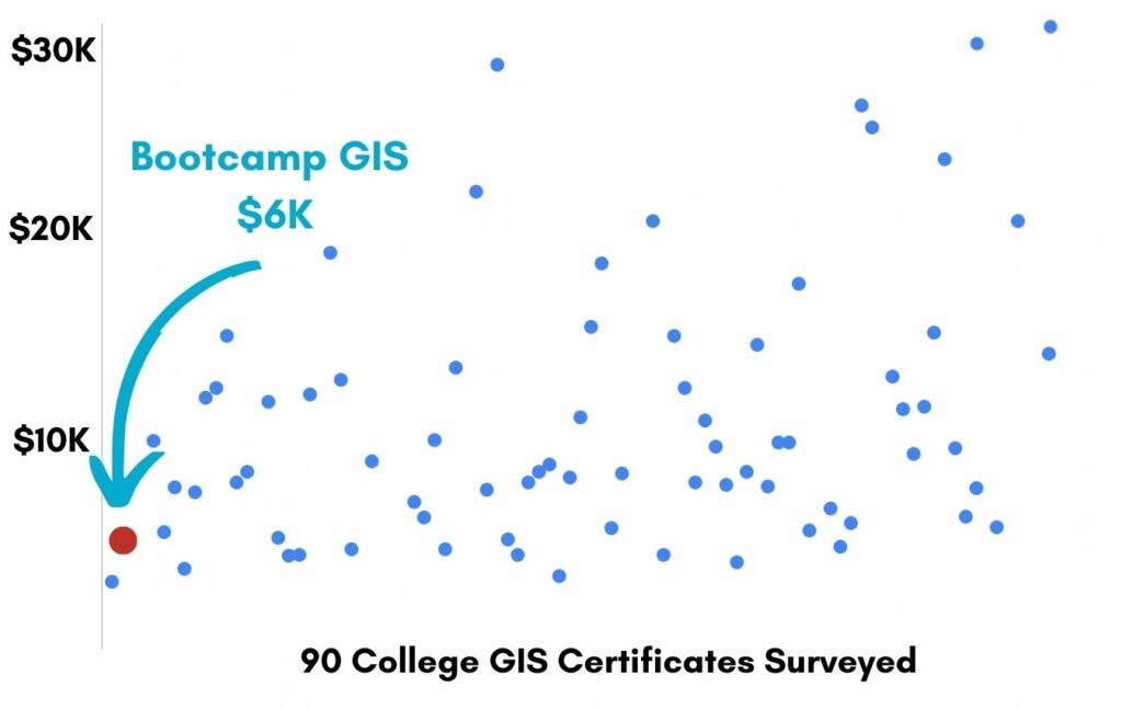
You’ve worked hard, but want better career results. Our program helps when…
Design a Field Data Collection Workflow: Smartphone to GIS Dashboard
Join this class to access to 9 modules to help you become the architect of your asset data collection workflow.
Millions of assets
(aka The city needs an efficient data collection workflow)
Apps that fit together
(aka The ArcGIS suite of apps)
The central map
(aka Design a web map for collaborative editing)
Collect your features
(aka Using Collector for field data entry)
The easy form
(aka Build your public form in Survey 123)
Coordinate the people
(aka Enable Workforce to manage your team in the field)
In the middle of nowhere
(aka Use a disconnected workflow)
The Dashboard
(aka Setup widgets in your realtime dashboard view)
Controlling access
(aka Use admin role to control privileges)
You also get access to these bonuses
Top 10 list of public data REST end-points
Value $49
Template data schemas for 4 field projects
Value $99
Ready to deploy ArcGIS Project Package
Value $199
Enter our online GIS program anytime.
It’s a flexible program. Pick just one course or complete any 6 to earn your GIS certificate.
Focus your learning where the best GIS jobs are.
A common GIS education path has been to pursue a Masters program in GIS. But it’s widely known in the industry that new geography grads are not getting enough exposure to cloud, mobile, and new geospatial programming environments.
So we assembled a world class team to teach you how to be the talent that the geospatial industry WILL HIRE. Compare the experience of our industry instructors and you’ll see why we top the list of best online GIS certificate programs.
Pricing
Knowledge Builder
$397
Online Anytime
Professional Builder
$697
Instructor Access
Plus these exclusive features:
Certificate Builder
$997
Earn Certification
Plus these exclusive features:
Plus college certification:
Compare Pricing
Earn your GIS Certificate in 6 months with flexible choice of classes.
Take the GIS classes you want, when you want, at the price level you want.
• Knowledge builder- asynchronous learning
• Professional builder- live instructor access
• Certificate builder- college certificate in GIS

Video Demos
Narrated industry stories and software demos

Exercises
Applied tasks using data and GIS software

Instructor Access
Instructor review and feedback on deliverables

Certification
Project sign off and college certification
Top reviews fromDesign A Field Data Collection Workflow: Smartphone To GIS Dashboard

30 Day 100% Risk Free Guarantee
Our Promise: Purchase this course today 100% risk free. When you enroll you get 30 days of reassurance that if the course isn’t right for you, you can request a refund.
Although all our students have loved the course so far, we want to make sure you get your value for money and find our product helpful. If you wish to proceed with a refund at any point, you will need to provide proof by submitting your project to show that you completed our instructional steps as we strongly believe in this product and only want committed students who care about getting results.
What can you achieve with these data workflow skills?
With these skills you will be equipped to setup a enterprise field data collection workflow using workforce or crowd sources.
Become the data workflow admin
You will design the field data collection process.
Configure mobile apps
You will leverage a core suite of Esri AGOL products.
Build city dashboards
You will architect the dashboard for central decision making.
Don’t settle for training that’s driven by people who don’t run projects.
When you learn from a Bootcamp GIS expert you get:
Technical experience
Industry insights
Professional network
About the Instructor

Shital Dhakal, GISP is a certified Geographic Information System (GIS) Consultant with more than a decade of experience in Esri’s Enterprise ArcGIS stack and product architecture. He has an extensive GeoSpatial portfolio working for private firms, governments, and academia in Asia, Europe, and North America. He is a published author of many peer-reviewed scientific publications. He holds a Master of Science degree and also has been certified by Esri and GISCI. He regularly presents in various national and international conferences like CalGIS, Esri User Conference, International Federation of Surveyors (FIG) Congress, etc. and is considered a thought leader in the applications of GIS technology for government workflows.
Why my course is useful
Local governments, big or small, rely on field data collection for monitoring progress, tracking and managing assets, responding to emergencies, managing workforce and supporting real time decision making. I share with students a data collection workflow that has these modern tech characteristics: low friction, mobile, crowdsourced, and real-time. Although this course is organized around data normally collected by municipalities, anyone working in State agencies, utilities, and academic institutions will benefit.
Why I built it
Personally I find myself spending a lot of time keeping up with changes in technology that impact workflows. The Bootcamp GIS paradigm has given me an outlet to share my knowledge for many other analysts and managers in local government that are seeking a timesaving and proven workflow in asset data collection. If I had a class like this when I started, it would have saved me a few months of tinkering.
What I hope for you
I hope you take the class and then two weeks later you have setup a robust field to server workflow for any city in the world. Seriously, you can do it!
Design a Field Data Collection Workflow: Smartphone to GIS Dashboard
Who is this class for?
The GIS industry is projected to be worth $18B by 2023. Despite this massive growth in new applications, there hasn’t been a single place for all of us to quickly learn tried and true skills from successful Subject Matter Experts (SMEs). Until Now! The people that purchase this course are:
College students and graduates looking to get fast track industry insights
Government professionals looking to retrain themselves and remain relevant
Corporate professionals looking to maintain a competitive advantage with relevant projects.
Talk to us and we’ll figure out your best path into the industry by suggesting project managers, companies, networks, and a GIS job recruiter. It’s simply the best GIS career advisement in the world.
Top reviews from Design A Field Data Collection Workflow: Smartphone To GIS Dashboard
I took this class becuase I only made maps in my classes and Shital showed me how to build data workflows.
Your course showed me a bunch of technology I’d never used. Glad I took it.
Shital you are a great guy to talk to and learn from. Keep up the good teaching.
Nice blend of software to learn in a complete solution.
This class had a lot of technology to keep track of. I got confused with 3 usecases in one class.