Develop a website with interactive maps to report water quality issues
In 2015, a report stated that nearly 21 million Americans were drinking water that violated health standards in the Safe Drinking Water Act. So how can we know? And how can we report suspect water? This class is for those who want to learn how to provide information, data, and visuals with easily accessible formats for citizens. Through this course, you will create interactive web apps that allow citizens to report problems with map locations and pictures using their mobile devices. The web apps are configurable and could be used for specific projects, such as making a water quality monitoring plan. By the end of this course, you will also create your own website to showcase those apps.
482 students enrolled
KEY PARTNERS:
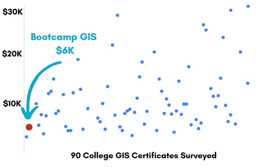
You’ve worked hard, but want better career results. Our program helps when…
Develop a website with interactive maps to report water quality issues
Join this class to access 10 modules showing how to build your map website.
Got bad water?
(aka Research local water problems)
Look around
(aka Explore effective web maps and apps)
Web development
(aka Create a WordPress website)
Gathering time
(aka Organize your water quality data)
Watershed event
(aka Watershed delineation)
Automate layers
(aka Script Python map routines)
Widget tinkering
(aka Design web app and map dashboard)
The public says
(aka Program a public data reporting tool)
The surroundings
(aka Use ArcGIS Pro overlay analysis)
Adding makeup
(aka Customized website and webmap functions)
You also get access to these bonuses
Model public web app list
Value $79
System architecture diagram
Value $159
Web app workflow guide
Value $199
Enter our online GIS program anytime.
It’s a flexible program. Pick just one course or complete any 6 to earn your GIS certificate.
Focus your learning where the best GIS jobs are.
A common GIS education path has been to pursue a Masters program in GIS. But it’s widely known in the industry that new geography grads are not getting enough exposure to cloud, mobile, and new geospatial programming environments.
So we assembled a world class team to teach you how to be the talent that the geospatial industry WILL HIRE. Compare the experience of our industry instructors and you’ll see why we top the list of best online GIS certificate programs.
Pricing
Knowledge Builder
$397
Online Anytime
Professional Builder
$697
Instructor Access
Plus these exclusive features:
Certificate Builder
$997
Earn Certification
Plus these exclusive features:
Plus college certification:
Compare Pricing
Earn your GIS Certificate in 6 months with flexible choice of classes.
Take the GIS classes you want, when you want, at the price level you want.
• Knowledge builder- asynchronous learning
• Professional builder- live instructor access
• Certificate builder- college certificate in GIS

Video Demos
Narrated industry stories and software demos

Exercises
Applied tasks using data and GIS software

Instructor Access
Instructor review and feedback on deliverables

Certification
Project sign off and college certification

30 Day 100% Risk Free Guarantee
Our Promise: Purchase this course today 100% risk free. When you enroll you get 30 days of reassurance that if the course isn’t right for you, you can request a refund.
Although all our students have loved the course so far, we want to make sure you get your value for money and find our product helpful. If you wish to proceed with a refund at any point, you will need to provide proof by submitting your project to show that you completed our instructional steps as we strongly believe in this product and only want committed students who care about getting results.
What can you achieve with these new skills?
With these skills you’ll be able to build web apps and maps
Collect water quality data
Find existing layers and do analysis for new layers
Design web maps and apps
Create interactive maps for allowing data entry
Build a public reporting website
Allow public to report water quality online
Don’t settle for training that’s driven by people who don’t run projects.
When you learn from a Bootcamp GIS expert you get:
Technical experience
Industry insights
Professional network
About the Instructor

Hideyuki has 15 years of experience as a GIS analyst, web developer, and data science instructor. He has applied his domain expertise in the water quality monitoring and forest conservation to work he has done for the Nature Conservancy, US EPA, the United Nations Environment Programme, and the University of Iowa. He currently works at the Green Infrastructure Center, where he creates interactive web maps/apps and develops automated workflows through Python scripts and Model Builder. In his free time, he enjoys spending time with his wife and daughters, growing organic foods at a community garden, and cooking for family and friends.
Why my course is useful
Web app development is now very popular because your work has greater value when more people can interact with your map data.
Why I built it
I’ve taught some standard intro to GIS courses in college. And the thing that interests students the most is my stories of real live work and applications. So I decided to create a course that is 100% applied with the actual steps in web GIS development that most organizations need.
What I hope for you
Many people can call themselves a GIS analyst. But few people can call themselves a Web GIS Developer. This role is needed in almost every GIS organization. I’d like you to build the next generation of web apps and web maps to replace the outdated product of taping a paper map to the wall.
Develop a website with interactive maps to report water quality issues
Who is this class for?
The GIS industry is projected to be worth $18B by 2023. Despite this massive growth in new applications, there hasn’t been a single place for all of us to quickly learn tried and true skills from successful Subject Matter Experts (SMEs). Until Now! The people that purchase this course are:
College students and graduates looking to apply to Web GIS developer jobs
GIS analysts looking to update their skills and remain relevant
Working professionals that want to learn digital mapping capabilities for a career change
Talk to us and we’ll figure out your best path into the industry by suggesting project managers, companies, networks, and a GIS job recruiter. It’s simply the best GIS career advisement in the world.
Top reviews from Develop A Website With Interactive Maps To Report Water Quality Issues
Learned a ton from your course!
This was the best course for GIS web development I’ve taken.
With this one class I can put python, WordPress, Model Builder, watersheds, and Esri Experience Builder on my resume. Best GIS project I’ve done.
I was so happy when my python data extraction scripts worked. Thanks for showing me Hideyuki.
The course gave detailed steps in every task. I learned way more in this class than an entire year in my college geog program.