Leveraging UAV (drone) Data for Environmental Projects
Do you want to gain field data collection skills within the UAV industry that is rapidly growing to a projected $64B annual spend? This class shows you how to be the Drone/GIS expert and generate value for your environmental projects.
822 students enrolled
KEY PARTNERS:
You’ve worked hard, but want better career results. Our program helps when…
Leveraging UAV Data for Environmental Projects
Join this class to access 10 modules that give you the ability to comprehensively execute Environmental UAV missions.
Earn your Wings
(aka Getting your UAV license)
Which Bird?
(aka Evaluate types of UAVs)
Finding the Work
(aka Identifying potential UAV projects)
Mission Planning
(aka Planning your UAV outing)
Taking Off
(aka Flying your UAV mission)
Make the Data Useful
(aka Data downloading and processing)
Identifying Life
(aka Biodiversity within vernal pools)
Is it or Is it Not?
(aka Identifying the vernal pool ponding extents)
Classifying Segments
(aka Image segmentation and classification concepts)
The Environmental Report
(aka Data and analysis that support the report)
You also get access to these bonuses
Mission planning prep checklist
Value $199
List of UAV test prep services
Value $299
Battery life / flight time matrix
Value $399
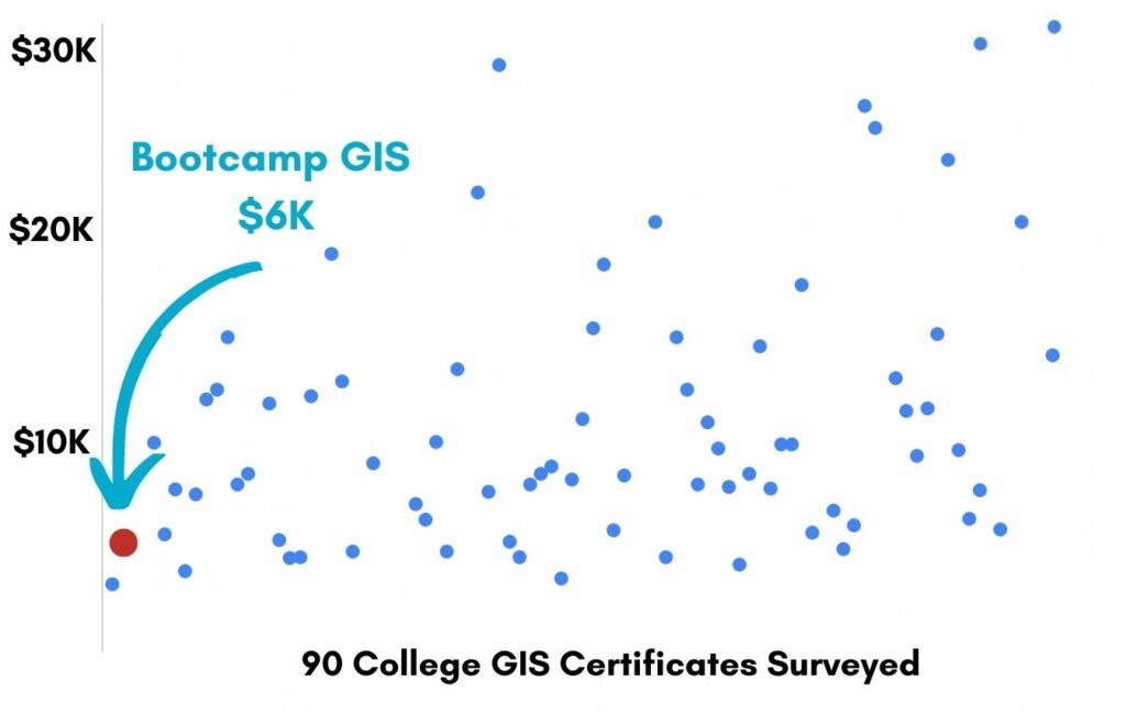
Enter our online GIS program anytime.
It’s a flexible program. Pick just one course or complete any 6 to earn your GIS certificate.
Focus your learning where the best GIS jobs are.
A common GIS education path has been to pursue a Masters program in GIS. But it’s widely known in the industry that new geography grads are not getting enough exposure to cloud, mobile, and new geospatial programming environments.
So we assembled a world class team to teach you how to be the talent that the geospatial industry WILL HIRE. Compare the experience of our industry instructors and you’ll see why we top the list of best online GIS certificate programs.
Pricing
Knowledge Builder
$397
Online Anytime
Professional Builder
$697
Instructor Access
Plus these exclusive features:
Certificate Builder
$997
Earn Certification
Plus these exclusive features:
Plus college certification:
Compare Pricing
Earn your GIS Certificate in 6 months with flexible choice of classes.
Take the GIS classes you want, when you want, at the price level you want.
• Knowledge builder- asynchronous learning
• Professional builder- live instructor access
• Certificate builder- college certificate in GIS

Video Demos
Narrated industry stories and software demos

Exercises
Applied tasks using data and GIS software

Instructor Access
Instructor review and feedback on deliverables

Certification
Project sign off and college certification

30 Day 100% Risk Free Guarantee
Our Promise: Purchase this course today 100% risk free. When you enroll you get 30 days of reassurance that if the course isn’t right for you, you can request a refund.
Although all our students have loved the course so far, we want to make sure you get your value for money and find our product helpful. If you wish to proceed with a refund at any point, you will need to provide proof by submitting your project to show that you completed our instructional steps as we strongly believe in this product and only want committed students who care about getting results.
What can you achieve with these UAV skills?
With these skills you will be able to collect UAV data and process it for your environmental report.
Get your UAV pilot’s license
We lead you towards preparation, testing, and certification.
Become the Drone/GIS expert
You will become essential in all your field projects.
Support environmental reporting
You will classify your imagery for your environmental reports.
Don’t settle for training that’s driven by people who don’t run projects.
When you learn from a Bootcamp GIS expert you get:
Technical experience
Industry insights
Professional network
About the Instructor

Frank McDermott has 20 years of experience in GIS with the last 16 years focused on the environmental sector. As the GIS/UAV manager for one of the most established environmental consulting firms in the Southwest, Frank has taken the lead on developing creative solutions to support client needs while protecting sensitive resources. He started their UAV program in 2017 shortly after the FAA developed it’s Part 107 commercial UAV licensing program. Since then he has flown over 100 missions for a variety of private and public sector clients.
Why my course is useful
I spent the better part of 2 months assessing technology and trying to figure out the best way to get a license and how to process the data. Once you take this course, you will have a tried and true workflow to plan, fly, and process data collected by your drone for habitat mapping.
Why I built it
For a long time, I wondered about the use of drones as a tool for our environmental GIS program. And once I got my license and started creating value added data for our projects, we saw new opportunities. So I’d like to help others to overcome their technical hesitation and learn the ROI of a good UAS program.
What I hope for you
I hope you can be part of the quickly growing UAV/UAS community. You’ll learn that the UAV is a key piece of hardware to go along with the GPS unit, server, and tablet to support your GIS practice. With better data you can inspire better environmental decisions. And it gets you out of the office for a day!
Leveraging UAV (drone) Data for Environmental Projects
Who is this class for?
The GIS industry is projected to be worth $18B by 2023. Despite this massive growth in new applications, there hasn’t been a single place for all of us to quickly learn tried and true skills from successful Subject Matter Experts (SMEs). Until Now! The people that purchase this course are:
College students and graduates looking to get fast track industry insights
Government professionals looking to retrain themselves and remain relevant
Corporate professionals looking to maintain a competitive advantage with relevant projects.
Talk to us and we’ll figure out your best path into the industry by suggesting project managers, companies, networks, and a GIS job recruiter. It’s simply the best GIS career advisement in the world.
Top reviews from Leveraging UAV (Drone) Data For Environmental Projects
Instructor worked in an environmental company and showed me how GIS is really done.
The only problem with this class is that now I need a drone to go out and complete a full project to gain confidence in the workflow.
Frank was really responsive to my emails and setting up meetings.
I skipped the FAA drone pilot license but went back after the course to pass this test.
Your course taught me about photogrammetry which wasn’t a class in my college.