Set up AWS map services for wildfire assessments
In 2020 the total of wildfire burned acreage is 6.6 million acres in the Western States, which is the most in a single year since records have been kept. It’s critical for organizations to quantify and plan for catastrophic events like fires. This course shows you how to setup an ArcGIS installation on AWS to house historical fire data to be used by regional stakeholders for fire planning.
616 students enrolled
KEY PARTNERS:
You’ve worked hard, but want better career results. Our program helps when…
Set up AWS map services for wildfire assessments
Join this class to access 10 modules that give you the ability to setup a property tax application.
Draw Up a Plan
(aka Diagram your architecture)
Enter the Cloud
(aka Create an AWS account and create an EC2 instance)
The Cornerstone Apps
(aka Install ArcGIS Server, web adapter, and Notebook Server)
Enduser Apps
(aka Install ArcGIS Pro and Notebook Server)
Lock and Key
(aka Define your users and permissions)
Scrape Your Data
(aka Consume fire and imagery data from public sources)
You’re a Publisher
(aka Publish a public and private web service)
Create New Knowledge
(aka Analyze your data using ArcGIS Pro and Python)
Insurance Policy
(aka Implement a backup strategy)
Sharing Your Analysis
(aka Create a wildfire analysis notebook)
You also get access to these bonuses
List of wildfire data sources
Value $99
A template
Value $159
A template
Value $199
Enter our online GIS program anytime.
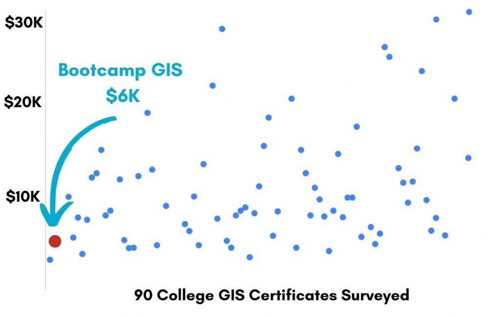
It’s a flexible program. Pick just one course or complete any 6 to earn your GIS certificate.
Focus your learning where the best GIS jobs are.
A common GIS education path has been to pursue a Masters program in GIS. But it’s widely known in the industry that new geography grads are not getting enough exposure to cloud, mobile, and new geospatial programming environments.
So we assembled a world class team to teach you how to be the talent that the geospatial industry WILL HIRE. Compare the experience of our industry instructors and you’ll see why we top the list of best online GIS certificate programs.
Pricing
Knowledge Builder
$397
Online Anytime
Professional Builder
$697
Instructor Access
Plus these exclusive features:
Certificate Builder
$997
Earn Certification
Plus these exclusive features:
Plus college certification:
Compare Pricing
Earn your GIS Certificate in 6 months with flexible choice of classes.
Take the GIS classes you want, when you want, at the price level you want.
• Knowledge builder- asynchronous learning
• Professional builder- live instructor access
• Certificate builder- college certificate in GIS

Video Demos
Narrated industry stories and software demos

Exercises
Applied tasks using data and GIS software

Instructor Access
Instructor review and feedback on deliverables

Certification
Project sign off and college certification

30 Day 100% Risk Free Guarantee
Our Promise: Purchase this course today 100% risk free. When you enroll you get 30 days of reassurance that if the course isn’t right for you, you can request a refund.
Although all our students have loved the course so far, we want to make sure you get your value for money and find our product helpful. If you wish to proceed with a refund at any point, you will need to provide proof by submitting your project to show that you completed our instructional steps as we strongly believe in this product and only want committed students who care about getting results.
What can you achieve with these new skills?
With these skills you will be equipped to setup an AWS server with an ArcGIS Enterprise deployment to perform analysis with publicly consumed data.
Become the GIS cloud architect
You will learn the AWS hosted environment.
Configure ArcGIS Enterprise
You will install, configure, and backup your applications.
Execute Python analysis on wildfire data
Consume REST services and run your scripts on public data.
Don’t settle for training that’s driven by people who don’t run projects.
When you learn from a Bootcamp GIS expert you get:
Technical experience
Industry insights
Professional network
About the Instructor

Aaron Kochman has a Master’s Degree in GIS Science from California State University – Long Beach and is currently the GIS Manager at the Fort Ord, CA cleanup. He has worked on a variety of enterprise projects that have utilized UAVs, LiDAR, virtual reality, data science, and web architecture. He has extensive experience with Esri products including ArcGIS Enterprise, ArcGIS Portal, ArcGIS Server, and ArcGIS Pro. As a private consultant, organizations rely on him to deploy cloud GIS serving architecture.
Why my course is useful
Almost every organization relies on cloud architecture for all their data and applications. This course gives the IT person a grounding in the world of GIS data, applications, and analysis. And it gives the GIS person a grounding in the IT architecture offered through AWS.
Why I built it
College was great, but I learned most of my technical skills outside of the college classroom. My experience was gained through trial and error and I sought out bootcamps and shortcourses to learn tech quickly. I’m excited about the future of GIS, cloud computing, and data science, and I’d like to inspire young talent around the globe to join this amazing career field.
What I hope for you
You are about to be cross-trained with talents in IT/GIS/Cloud. I’m a great example where this talent quickly pushed me up the professional ladder. I’m confident that this portfolio item will get you a job!
Setup AWS map services for wildfire assessments
Who is this class for?
The GIS industry is projected to be worth $18B by 2023. Despite this massive growth in new applications, there hasn’t been a single place for all of us to quickly learn tried and true skills from successful Subject Matter Experts (SMEs). Until Now! The people that purchase this course are:
College students and graduates looking to get fast track industry insights
Government professionals looking to retrain themselves and remain relevant
Corporate professionals looking to maintain a competitive advantage with relevant projects.
Talk to us and we’ll figure out your best path into the industry by suggesting project managers, companies, networks, and a GIS job recruiter. It’s simply the best GIS career advisement in the world.
Top reviews from Learn Set Up AWS Map Services For Wildfire Assessments
Aaron responds quickly to your problems. I had many questions he quickly answered.
This class could have gone more into the wildfire assessment process but I learned plenty about AWS.
Highly recommend learning GIS within AWS in Aaron’s class.
As a geography major, AWS was scary to me. Not any more.
I can see how cloud computing skills are a must for any GIS analyst. Good lessons here.