Automate data conversion into an AWS GIS repository
In the architecture, engineering, and construction (AEC) industry, spatial and other data is streaming from different sources with many inherent problems. Every organization needs a data architect to automate corrections and conversions from all this data. This course teaches you how to configure AWS and FME for rapid automation, conversion, conflation, and analytics of raw data into a seamless database that supports more intelligent display and decision making. This allows you to become a master instead of a slave to your data.
339 students enrolled
KEY PARTNERS:
You’ve worked hard, but want better career results. Our program helps when…
Automate data loading into an AWS GIS repository
Join this class to access 9 modules that give you the ability to automatically extract, transform, and load (ETL) data into an AWS data repository for the AEC industry.
Your Data has Issues
(aka Assess your data for problems)
Eureka!
I’ve got it.
(aka Diagram a data automation solution)
Buckets of Data
(aka Setup an AWS server with bucket data containers)
Do you read me, over?
(aka Setup AWS SQS communications)
Using an Interpreter
(aka Process JSON messages from events)
The Workbench
(aka Customize a workspace for downloaded files)
The Makeover
(aka Perform data conversions)
Your Serve
(aka Use FME Cloud to create a server instance)
The Repository Benefits
(aka Web access to a clean data repository for AEC)
You also get access to these bonuses
Custom GIS to CAD Conversion workflow diagram
Value $79
1 FME Server process scripting routine
Value $159
3 FME data scripting routines
Value $199
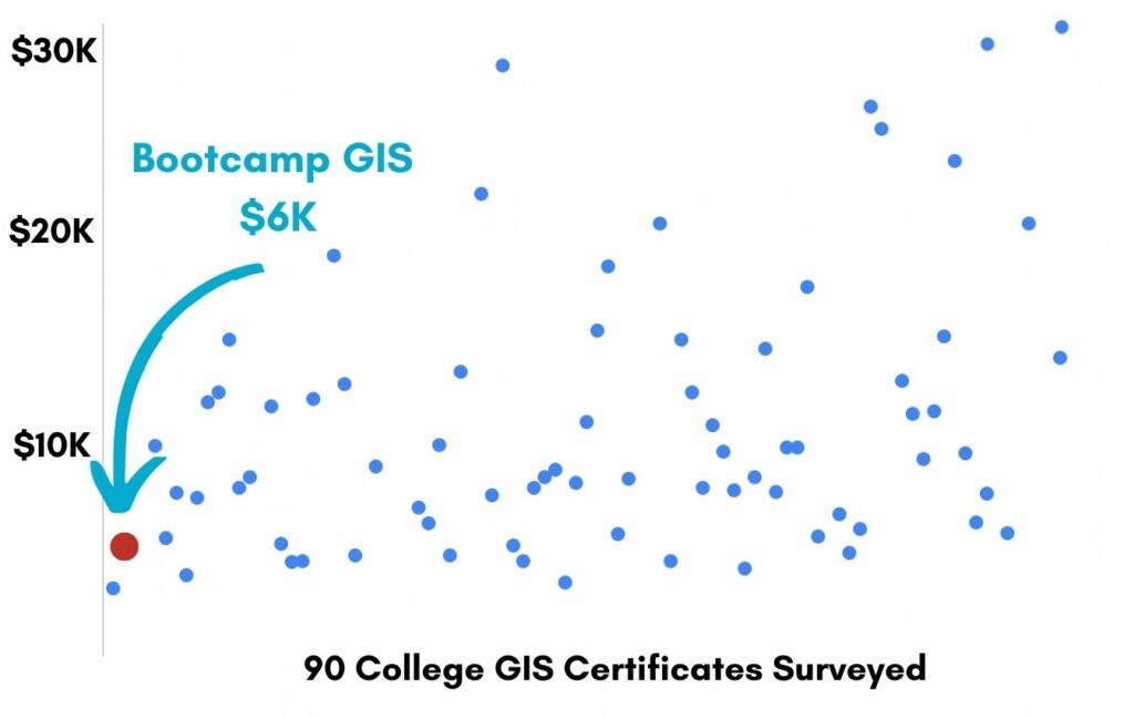
Enter our online GIS program anytime.
It’s a flexible program. Pick just one course or complete any 6 to earn your GIS certificate.
Focus your learning where the best GIS jobs are.
A common GIS education path has been to pursue a Masters program in GIS. But it’s widely known in the industry that new geography grads are not getting enough exposure to cloud, mobile, and new geospatial programming environments.
So we assembled a world class team to teach you how to be the talent that the geospatial industry WILL HIRE. Compare the experience of our industry instructors and you’ll see why we top the list of best online GIS certificate programs.
Pricing
Knowledge Builder
$397
Online Anytime
Professional Builder
$697
Instructor Access
Plus these exclusive features:
Certificate Builder
$997
Earn Certification
Plus these exclusive features:
Plus college certification:
Compare Pricing
Earn your GIS Certificate in 6 months with flexible choice of classes.
Take the GIS classes you want, when you want, at the price level you want.
• Knowledge builder- asynchronous learning
• Professional builder- live instructor access
• Certificate builder- college certificate in GIS

Video Demos
Narrated industry stories and software demos

Exercises
Applied tasks using data and GIS software

Instructor Access
Instructor review and feedback on deliverables

Certification
Project sign off and college certification

30 Day 100% Risk Free Guarantee
Our Promise: Purchase this course today 100% risk free. When you enroll you get 30 days of reassurance that if the course isn’t right for you, you can request a refund.
Although all our students have loved the course so far, we want to make sure you get your value for money and find our product helpful. If you wish to proceed with a refund at any point, you will need to provide proof by submitting your project to show that you completed our instructional steps as we strongly believe in this product and only want committed students who care about getting results.
What can you achieve with these new skills?
With these skills you will be equipped to run FME data cleansing and conflation routines to setup an enterprise AWS data repository.
Become the data architect
You will assess, fix, and load vast amounts of data
Configure AWS and FME services
You will create an automatically populating database
Maintain a cloud data repository
You will serve data to a large AEC audience
Don’t settle for training that’s driven by people who don’t run projects.
When you learn from a Bootcamp GIS expert you get:
Technical experience
Industry insights
Professional network
About the Instructor

Kevin Weller has 30 years experience as a software architect and systems integrator with expertise in GIS, FME, Python, Django, Ruby, and Rails. He specializes in web and cloud-based architectures, with private industry clients in energy, finance, healthcare, hospitality, real estate, and architecture/engineering/construction/operations. In recent years, he has built geospatial solutions as varied as self-service geospatial data extraction applications, automated data analytics engines, and complex CAD-to-GIS / GIS-to-CAD conversion systems.
Why my course is useful
In the AEC industry, spatial and other data comes from different sources with many inherent problems, including low quality and incompatibility with different applications. And it keeps coming, and coming, and coming. Every organization and project needs the skills of a central data architect to manage it all.
Why I built it
I want my students to learn data management techniques based on my real-world systems experience. Managing data may not seem sexy, but it’s critical for large enterprises. You probably realize how difficult it is to just manage the files on your own laptop. Magnify that challenge by 1000x and you’ll see a glaring industry need. I’d like to make a difference by coaching new data architects because unorganized data can be just as bad as no data.
What I hope for you
Now more than ever, companies desperately need ways to streamline their operations and produce valuable insights using their location-intelligent data. I want you to learn these skills and become their data savior!
Automate data conversion into an AWS GIS repository
Who is this class for?
The GIS industry is projected to be worth $18B by 2023. Despite this massive growth in new applications, there hasn’t been a single place for all of us to quickly learn tried and true skills from successful Subject Matter Experts (SMEs). Until Now! The people that purchase this course are:
College students and graduates looking to get fast track industry insights
Government professionals looking to retrain themselves and remain relevant
Corporate professionals looking to maintain a competitive advantage with relevant projects.
Talk to us and we’ll figure out your best path into the industry by suggesting project managers, companies, networks, and a GIS job recruiter. It’s simply the best GIS career advisement in the world.
Top reviews from Automate Data Conversion Into An AWS GIS Repository
FME is a good tool to learn and I’m glad I took your class.
This is a very technical class that is more about data than maps. I can see how this would be useful for a small group of data architects.
In college I never learned data architect skills. Thank for your class Kevin.
Mr Weller, you are blackbelt with handling data with FME.
I didn’t know I needed this class until I took it. I’m comfortable with the idea of data automation.now.