Showing 1–12 of 32 results
-

3-month Support Extension
$400.003-month Support Extension Need more time to complete your certificate? Not a problem since we know that life happens. This extends your support for software licensing, instructor access, and career services for 3 additional months beyond your original 6 month program purchase. KEY PARTNERS: Enter our online GIS program anytime. It’s a flexible program. Pick…
-
6-Course Certificate Builder Bundle
$397.00 – $5,675.006-Course GIS Certificate Builder Bundle (Save $300) Compared to most other GIS programs, we are HALF THE COST, HALF THE TIME. Purchase our 6 course certificate and save money. Compare our curriculum of applied course projects to any other GIS education program in the world and you will find that this is the best student portfolio…
-

Add a GIS planning project to your portfolio in a week
Add a GIS planning project to your portfolio in a week Many people get a college degree, but they have the challenge of demonstrating applied project experience on their portfolio. GIS is one of the applied technical tools that can be used to quickly demonstrate technical prowess no matter your field of study. In this…
-
Agile Management of a Modern GIS
$397.00 – $997.00Agile Management of a Modern GIS You get hired as an analyst. Maybe you even get promoted to lead GIS activities or manage people. But did you ever get trained to manage a GIS using modern architecture? This class saves you time with 10 document templates to do this successfully within the evolving tech landscape….
-
Apply geospatial web tools to large scale forest planning
$397.00 – $997.00Apply geospatial web tools to large scale forest planning Do you want to work for a federal or state forest agency and be involved in long term forest planning? The US Forest Service manages 193 million acres and is required to inform internal and external stakeholders within this process. This class is for those…
-
Automate data conversion into an AWS GIS repository
$397.00 – $997.00Automate data conversion into an AWS GIS repository In the architecture, engineering, and construction (AEC) industry, spatial and other data is streaming from different sources with many inherent problems. Every organization needs a data architect to automate corrections and conversions from all this data. This course teaches you how to configure AWS and FME for…
-
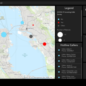
Build a dashboard for a COVID-19 hotline calling system
$397.00 – $997.00Build a dashboard for a COVID-19 hotline calling system The COVID-19 pandemic is the most serious health threat of our lifetime. Regional agencies have looked to convey specific types of COVID-19 case data such as the information coming in from hotline calls from the public. This course will teach you how to collect, visualize, and…
-
Building a GIS Data Portal for Emergency Services
Building a GIS Data Portal for Emergency Services Every city and county requires an authoritative and reliable geographic portal to support emergency services needs. Students will learn how to prepare and evaluate data as they harvest internal and external GIS data resources. This course will take students through the configuration process of building backend infrastructure…
-
COMING SOON Build a stadium navigation app with ArcGIS Indoors
Build a stadium navigation app with Indoors GIS Navigation is not just needed when driving a car. Now it can used to walk a complex path within a sports complex. Get ahead of the curve in the geospatial revolution with our immersive course on Indoor and 3D GIS. Indoor GIS manages geographic data within structures….
-
COMING SOON Build an ArcGIS Hub to Promote Environmental Justice
Build an ArcGIS Hub to promote environmental justice Everyone – regardless of race, skin color, national origin, or income – has the right to the same environmental protections and benefits. One actional step towards alleviating environmental injustice, is to monitor a city’s tree canopy. Improving a city’s urban tree canopy can have numerous benefits including…
-
COMING SOON Create a drought time series in Google Earth Engine
Coding a drought time series in Google Earth Engine Climate change is being studied by everyone from the United Nations, to NOAA, to your local city. One of the key indicators is increasing drought. Today, 40% of the World population has suffered water scarcity. In this class you will code a machine learning workflow with…
-
COMING SOON Develop GeoAI models for precision agriculture
Develop GeoAI models for precision agriculture The World’s population is growing to 8.5B by 2030 and to address our food needs we will have to produce higher yields. This is a one of a kind course that will teach you the technical intricacies of leveraging GeoAI to revolutionize agricultural practices. We will equip you with…