Build a stadium navigation app with Indoors GIS
Navigation is not just needed when driving a car. Now it can used to walk a complex path within a sports complex. Get ahead of the curve in the geospatial revolution with our immersive course on Indoor and 3D GIS. Indoor GIS manages geographic data within structures. From urban planning to facility management, these advanced techniques are transforming the way we interact with our surroundings. You will learn these cutting-edge technologies that are needed by engineering and urban planning firms. There is a bright future in using Indoors in conjunction with many IOT services that are controlled via location.

KEY PARTNERS:
You’ve worked hard, but want better career results. Our program helps when…
Build a stadium navigation app with ArcGIS Indoors
Join this class to access 10 modules showing how to create indoors navigation.
Lets go inside
(aka Review the stadium usecase)
3D experience
(aka Connect Indoor, 3D, and digital twins)
Data dimensions
(aka Create data in 3D)
Connective tissue
(aka Build the network dataset)
Everything OK?
(aka Locate errors and fix)
Find your way
(aka Build the stadium navigation logic)
Let it work
(aka Automate the Indoor GIS processes)
Going online
(aka Publish your routing service )
Strive for perfection
(aka Perform data quality assurance)
What next?
(aka Customize your application with extensions)
You also get access to these bonuses
Stadium digital twin
Value $79
Spatial Model template
Value $159
ArcGIS Indoors workflow
Value $199
Enter our online GIS program anytime.
It’s a flexible program. Pick just one course or complete any 6 to earn your GIS certificate.
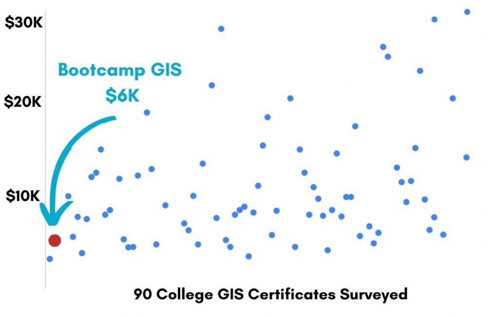
Focus your learning where the best GIS jobs are.
A common GIS education path has been to pursue a Masters program in GIS. But it’s widely known in the industry that new geography grads are not getting enough exposure to cloud, mobile, and new geospatial programming environments.
So we assembled a world class team to teach you how to be the talent that the geospatial industry WILL HIRE. Compare the experience of our industry instructors and you’ll see why we top the list of best online GIS certificate programs.
Pricing
Knowledge Builder
$395
Online Anytime
Professional Builder
$697
Instructor Access
Plus these exclusive features:
Certificate Builder
$997
Earn Certification
Plus these exclusive features:
Plus college certification:
Compare Pricing
Earn your GIS Certificate in 6 months with flexible choice of classes.
Take the GIS classes you want, when you want, at the price level you want.
• Knowledge builder- asynchronous learning
• Professional builder- live instructor access
• Certificate builder- college certificate in GIS

Video Demos
Narrated industry stories and software demos

Exercises
Applied tasks using data and GIS software

Instructor Access
Instructor review and feedback on deliverables

Certification
Project sign off and college certification

30 Day 100% Risk Free Guarantee
Our Promise: Purchase this course today 100% risk free. When you enroll you get 30 days of reassurance that if the course isn’t right for you, you can request a refund.
Although all our students have loved the course so far, we want to make sure you get your value for money and find our product helpful. If you wish to proceed with a refund at any point, you will need to provide proof by submitting your project to show that you completed our instructional steps as we strongly believe in this product and only want committed students who care about getting results.
What can you achieve with these new skills?
With these skills you’ll be able to build an indoor navigation service.
Create a digital twin
Build the 3D model for a stadium
Network a dataset
Create a dataset used for navigation
Publish the service
Share your navigation app to the web
Don’t settle for training that’s driven by people who don’t run projects.
When you learn from a Bootcamp GIS expert you get:
Technical experience
Industry insights
Professional network
About the Instructor

Sri Krishna Murthy Hari has 12 years of experience as a GIS developer. He currently works at Beans.AI where he designs precision indoor location solutions. His groundbreaking contributions have earned him prestigious accolades such as Geospatial World 50 Rising Stars’23, xyHT 23 Young Geospatial Pros 23, and ESRI AEC GIS Hero 2023. Away from his professional pursuits, Sri Krishna is an avid sports enthusiast, with a particular love for badminton and cricket.
Why my course is useful
Every city is building new structures. And when they get old, they modernize and rebuild them. The use of Indoors datasets, 3D networking, and digital twins is needed in almost every AEC (architectural, engineering, construction) project.
Why I built it
I found that my college classes focused too much on readily available municipal datasets like parcels or landscape datasets like watersheds. As I got into industry, I could see abundant opportunities to use more structural datasets to bring spatial intelligence to any building or complex. But a course was needed to help more people gain these skills.
What I hope for you
I’d like people to take these skills and become employed with engineering companies or IOT service companies. For most of these organizations, you could be leading the charge with smart Indoors integrations. And I want you to become the GIS guru they will lean on for every project.
Build a stadium navigation app with ArcGIS Indoors
Who is this class for?
The GIS industry is projected to be worth $200B by 2030. Despite this massive growth in new applications, there hasn’t been a single place for all of us to quickly learn tried and true skills from successful Subject Matter Experts (SMEs). Until Now! The people that purchase this course are:
College students and graduates looking to become marketable in the AEC industry
Government professionals looking to retrain themselves and remain relevant
Corporate professionals looking to maintain a competitive advantage with relevant projects.
Talk to us and we’ll figure out your best path into the industry by suggesting project managers, companies, networks, and a GIS job recruiter. It’s simply the best GIS career advisement in the world.