Leveraging GIS for Disaster Risk Reduction
Do you want to be involved with your city, county, or local Federal office planning that is in charge making your community safer? This class is for those that want to learn how GIS can proactively prepare communities for potential disasters.
455 students enrolled
KEY PARTNERS:
You’ve worked hard, but want better career results. Our program helps when…
Leveraging GIS for Disaster Risk Reduction (DRR)
Join GIS for DRR and get access to 9 modules that give you the template to create your own GIS-Centric Disaster Risk Reduction analysis platform.
Disaster Risk Primer
(aka Understanding the Forest Planning Rule)
The Box of Reason
(aka How to scope and plan for long term success)
Knowing the Players
(aka Get active with community building)
Top to Bottom Profile
(aka Develop a hazard profile for your region)
Hazards Everywhere
(aka Map out hazards and safe areas)
Understanding Exposure
(aka Proactively look at your community assets)
Weighing the Risks
(aka Geospatial risk analysis)
Informing without Alarming
(aka Communicating and planning)
Deal with the Dynamics
(aka Evolving the analysis as you learn more)
You also get access to these bonuses
Planning templates and meeting facilitation tools
Value $99
Access to an experienced practitioner’s insights
value $129
Assessment approach to community needs
value $199
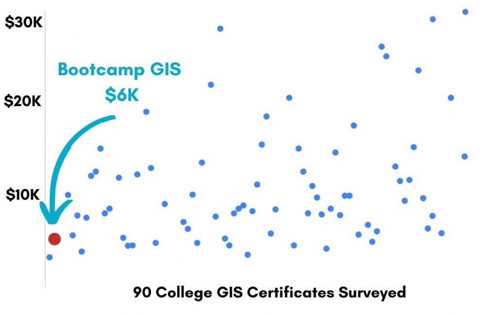
Enter our online GIS program anytime.
It’s a flexible program. Pick just one course or complete any 6 to earn your GIS certificate.
Focus your learning where the best GIS jobs are.
A common GIS education path has been to pursue a Masters program in GIS. But it’s widely known in the industry that new geography grads are not getting enough exposure to cloud, mobile, and new geospatial programming environments.
So we assembled a world class team to teach you how to be the talent that the geospatial industry WILL HIRE. Compare the experience of our industry instructors and you’ll see why we top the list of best online GIS certificate programs.
Pricing
Knowledge Builder
$397
Online Anytime
Professional Builder
$697
Instructor Access
Plus these exclusive features:
Certificate Builder
$997
Earn Certification
Plus these exclusive features:
Plus college certification:
Compare Pricing
Earn your GIS Certificate in 6 months with flexible choice of classes.
Take the GIS classes you want, when you want, at the price level you want.
• Knowledge builder- asynchronous learning
• Professional builder- live instructor access
• Certificate builder- college certificate in GIS

Video Demos
Narrated industry stories and software demos

Exercises
Applied tasks using data and GIS software

Instructor Access
Instructor review and feedback on deliverables

Certification
Project sign off and college certification

30 Day 100% Risk Free Guarantee
Our Promise: Purchase this course today 100% risk free. When you enroll you get 30 days of reassurance that if the course isn’t right for you, you can request a refund.
Although all our students have loved the course so far, we want to make sure you get your value for money and find our product helpful. If you wish to proceed with a refund at any point, you will need to provide proof by submitting your project to show that you completed our instructional steps as we strongly believe in this product and only want committed students who care about getting results.
What can you achieve with these DRR skills?
With these skills you will be equipped to lead or contribute to any regional Disaster Risk Reduction plan.
Become Central to DRR
You will learn how to be central in the Disaster Risk Reduction process.
Define Hazards
You will learn how to define hazard areas and inventory assets that shed light on potential disaster consequences.
Engage the Community
You will learn how your ArcGIS Online products can compel a community toward improved and more dynamic disaster planning.
Don’t settle for training that’s driven by people who don’t run projects.
When you learn from a Bootcamp GIS expert you get:
Technical experience
Industry insights
Professional network
About the Instructor

Since 1992 Nate has worked at the confluence of geospatial information and disaster management in both the domestic and international domains. He has been a pioneer in this discipline though his work at USAID’s Office of Foreign Disaster Assistance, FEMA’s GIS Solutions Branch, and the DHS Geospatial Management Office. He draws on his field experience as an emergency first responder and international humanitarian. Nate has taught this course at a number of universities.
Nate spends his free time playing, coaching or cheering on his kids at lacrosse throughout the Eastern half of the US. Beyond lacrosse, a perfect day includes hiking historical landscapes to better understand the past and connect with great events and those that lived through them.
Why my course is useful
This course ties together the disciplines of disaster management, planning and GIS in a way that allows them to exceed the sum of their parts and make communities safer. I believe that once you take this course you will see the world in a different, more integrated way and better understand how you can make your community safer, while also developing your career goals.
Why I built it
Following years of supporting disaster response with GIS capability, I came to realize that response was too late! It became clear that GIS had the potential to help communities break the formula of vulnerability and keep these tragedies from occurring in the first place. However, GIS could not do it alone as it takes good science, quality data and an understanding of planning and communications to really affect change.
What I hope for you
My hope is that you and those you train will see the value in these tools and approached and use them to make your communities safer. I also hope that your contributions will be recognized and that your career will advance and as you ascend, this approach will become widely adopted at the highest levels of government and the community.
Leveraging GIS for DRR
Who is this class for?
The GIS industry is projected to be worth $18B by 2023. Despite this massive growth in new applications, there hasn’t been a single place for all of us to quickly learn tried and true skills from successful Subject Matter Experts (SMEs). Until Now! The people that purchase this course are:
College students and graduates looking to get fast track industry insights
Government professionals looking to retrain themselves and remain relevant
Corporate professionals looking to maintain a competitive advantage with relevant projects.
Talk to us and we’ll figure out your best path into the industry by suggesting project managers, companies, networks, and a GIS job recruiter. It’s simply the best GIS career advisement in the world.
Top reviews from Leveraging GIS For Disaster Risk Reduction
Nate I loved each of our meetings and learning from you.
Good course to see how GIS planning is necessary for any community that is susceptible to a disasters.
Thanks Nate for our down to earth conversations about community planning and gis.
Easy class to learn gis webmaps for planning.
The instructor talks a lot about the people and conversations needed for disaster planning. Simple GIS is all that is needed.