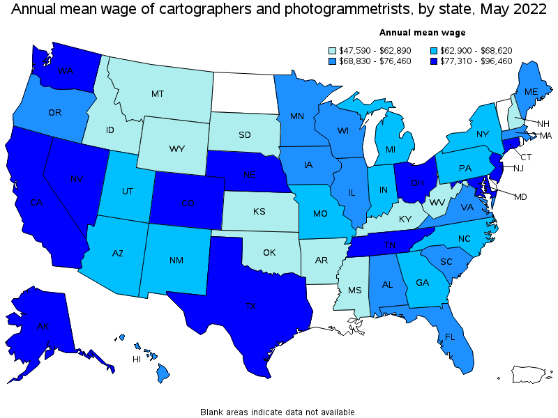
5 Hidden GIS Job Opportunities
You should be looking at these lesser know vertical industries
Most people know about urban and conservation applications of GIS Programs Online. This is because many professors and curriculum workflows use these types of use cases with a city or a federal dataset. But here are a few new areas you should be looking for job opportunities.
Green Energy using GIS
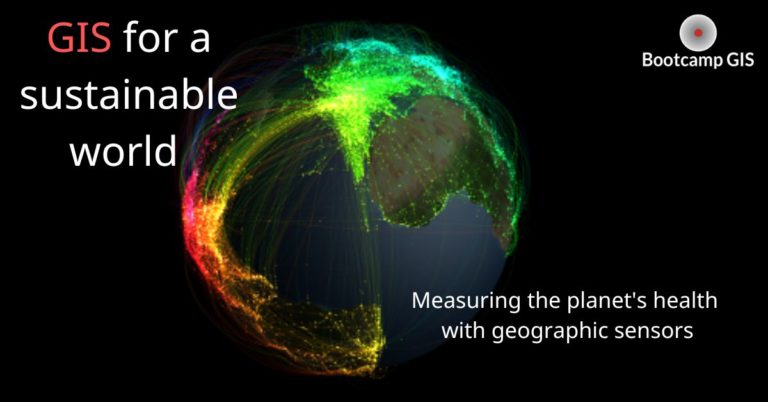
Geographic Information Systems play a pivotal role in the green energy sector, revolutionizing how we plan, implement, and manage sustainable energy resources. the mapping programs enable precise analysis of renewable energy potential, aiding in site selection of green projects by considering factors like topography, sunlight exposure, and wind patterns. Advanced technologies using these systems integrate real-time data, facilitating efficient energy grid management and optimizing the distribution of renewable resources. Additionally, GIS supports environmental impact assessments, enhancing decision-making processes to minimize ecological footprints. Ongoing technological advancements, such as machine learning and remote sensing integration further enhance capabilities of geographic information systems, while providing invaluable tools for promoting the transition to a cleaner and more sustainable energy future.
Excellent organizations offering jobs for GIS analyst include,
Insurance for GIS Programs Purposes
The future of the GIS industry will also be heavily involved in the insurance industry, which can be marked by transformative technological advancements in computing used for statistical analysis. These geographic technology systems are becoming increasingly consolidated into the insurance industry to assess risk with spatial precision, enabling insurers to better understand and manage exposure to natural disasters. Emerging technologies like artificial intelligence and machine learning enhance predictive modeling, allowing insurers to further refine risk assessments and streamline claims processes. This inclusion is helping to develop a more robust data-driven and efficient insurance landscape, facilitating quicker responses to claims and bolstering resilience against emerging risks associated with climate change and other dynamic factors.
Excellent organizations offering jobs for GIS analyst include,
Healthcare Mapping
GIS also plays an essential role in healthcare, creating user friendly spatial data tools to enhance decision-making and resource allocation. GIS is crucial for mapping disease patterns, optimizing healthcare facility locations, and identifying areas with health disparities. In the healthcare field, professionals contribute to epidemiological research, public health planning, and emergency response strategies. Job opportunities in healthcare increasingly demand expertise with geographic information systems, with roles like health geographer and GIS analyst producing things like COVID Map Dashboards. These professionals help develop a more efficient and equitable healthcare system by the power of spatial analysis and geospatial technology.
Companies in healthcare seeking geographers,
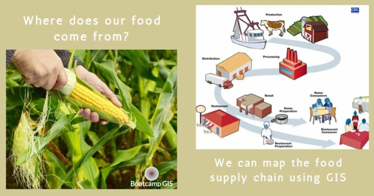
Agriculture Mapping
In agriculture, online GIS certificate programs are employed for soil mapping, crop monitoring, yield prediction, optimizing resource use, and enhancing procedural efficiency. Advanced GIS technologies, such as remote sensing and GPS integration, enable real-time monitoring of field conditions, improving crop governance practices. Drones equipped with GIS capabilities provide high-resolution imagery for detailed field analysis. Precision agriculture, powered by geographic information systems minimizes environmental impact, maximizes yields, while also helping develop sustainable farming customs. Ongoing applications using these technologies have proven to support every aspect of the Agriculture and Food industry seen below.
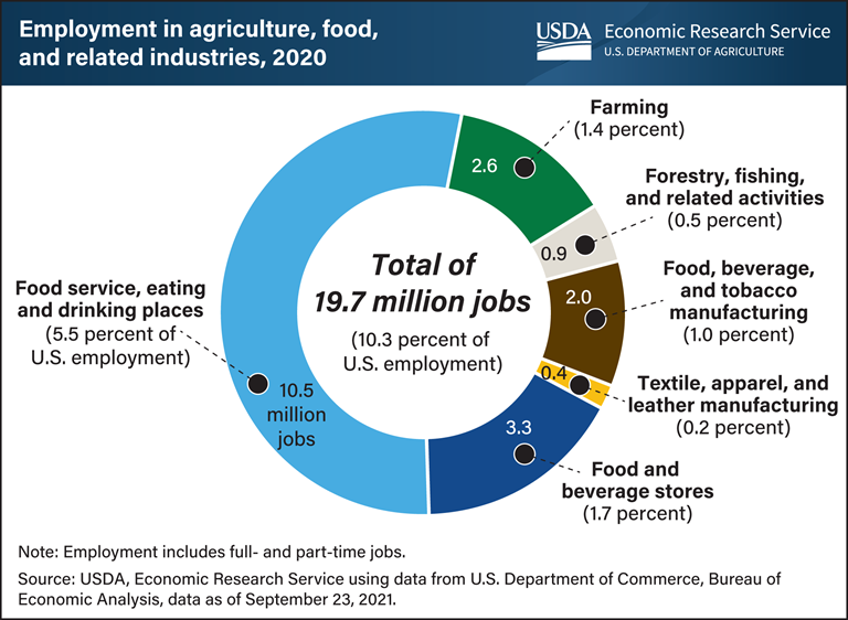
Excellent organizations offering jobs for agricultural geographers,
Supply Chain Mapping
And finally, Geographic Information Systems are revolutionizing the global logistics and supply chain industry by providing unparalleled spatial insights. During COVID we had to take a hard look at interruptions in the supply chain to get things like car and computer parts. GIS optimizes route planning, inventory management, and distribution networks, reducing operational costs and enhancing efficiency. Real-time tracking of shipments, warehouse optimization, and risk/ probability assessment are facilitated through these systems, allowing for enterprising decision-making. The blending of GIS into supply chain management is evolving rapidly, driven by advancements in sensor technology, Internet of Things (IoT), and cloud computing. As businesses increasingly recognize the value of location intelligence of these systems they are becoming a core component in supply chain strategies, improving visibility, resilience, and responsiveness in a high-powered global market.
Excellent organizations offering jobs for supply chain analyst,
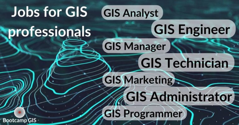
Many Jobs in GIS
So, we advise you to begin looking for opportunities in rewarding career pathways and further training to become a cartographic analyst. This requires extensive knowledge of hard sciences, mapmaking principles, and spatial visualization skills. The most marketable skills are listed in the GIS Jobs Report. To obtain these skills, you might consider getting a geography degree from a university. But take special care that you don’t run into curriculum limitations with an absence of web mapping or newer geospatial programming environments as this has become an emerging reason new graduates are not able to find a job after graduating.
A shorter and cheaper path is to earn a certification. At Bootcamp GIS you could get an enterprise certification in geographic information systems by completing 6 project-based courses in 6 months at about half the cost of most university certificates. There is also flexibility in the start date in that the courses are online with the world’s best career services support included for every student. If interested, you can book a free GIS advisement session. Whatever path you choose, GIS is a great way to tech-enable your career.