Mapping with drones: Best places to learn

3D mapping with drones

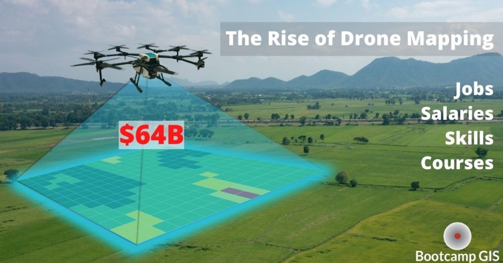
If you like to play with drones (UAV) and you want to turn your passion into a profession, you should check out the growing industry of drone mapping.  It is a $64B industry that is one of the key data collection sources for Geographic Information Systems (GIS).  Within GIS, UAVs are used within photogrammetry and LiDAR workflows to create images and videos that can be geospatially located on a map.  Drone mapping collects data and does aerial surveys with professional cameras. It’s 90% faster than manual methods of walking around doing fieldwork.  With this imagery you can create 3D models and get precision measurements.  Examples are 3D models of a new building, imagery for maintenance of utility towers, and vegetation canopy heights and health measurements.  This skill can be added to your portfolio using some of the following resources.

How to become a drone pilot

Do you want to fly UAVs for professional projects?  You will need a UAV pilot license before officially being a commercial drone pilot which is different than recreational UAV flying.  The Federal Aviation Administration (FAA) authorizes pilot certificates to prove that you have the skills to safely fly a drone.  This is a legal requirement under part 107 of the FAA’s Small Unmanned Aircraft Systems (UAS) Rule.  The Part 107 test requires some study.  But no worries, I have three good drone pilot exam course suggestions for you. 

  1. The Pilot Institute is a large volume testing administrator.  More than 35,148 people took their classes and almost 100% of them passed the FAA exam.  You will get a full refund of the course and the test center fee if you don’t get a pass.  They will also provide you with more than 300 questions as a practice for the exam. 
  2. The Drone Launch Academy helped more than 15,000 people pass the FAA exam.  Their students get a 99.54% passing rate on the exam.  They will give you money back for the course and compensate your test center fee if you don’t pass the FAA exam for the first time.  You will get some free bonuses by purchasing their Part 107 exam course. 
  3. The Drone Pilot Ground School offers you a refund of the courses and covers your test center fee if you don’t pass the FAA exam.  The passing rate of their students taking the FAA exam for the first time is 99%. 

Drone mapping courses

The best suggestion for you to enter the UAV industry is to enhance your skills in collecting data. It’s much better to be known as an expert in both UAVs and GIS.  I have some good choices and suggestions for you.  

  1. Bootcamp GIS provides a UAV mapping course to support your environmental projects by teaching you how to leverage UAV data. This can be one course towards a complete GIS certificate
    Price: $397
    Duration: 4 weeks
  2. Dartdrones has a DroneDeploy Workshop for you to learn about aerial mapping and modeling.
    Price: $1490
    Duration: 2 days
  3. ABJ Drone Academy has a drone surveying and 3D modeling course to give you knowledge of how drones can provide useful data for different industries. 
    Price: $200
    Duration: 3 to 6 hours

It’s exciting to be part of this cool industry!  You can learn skills, get solutions, and gain connections in a variety of disciplines that need this data.

Drone mapping jobs

There are many opportunities in the UAV industry.  You can choose to be a freelance drone pilot or work for a company.  The market for drone piloting is increasing as evidenced by this skill showing up in many more job announcements.  For example, some real estate agencies are looking for drone pilots to take photos and create videos for them.  You can find many job listings through Indeed.  A UAV pilot makes an average of $58K a year in the US.  If you combine good GIS data and analysis skills, then you’ll be able to complete for higher GIS salaries.  

Conclusion:  Drone mapping is full of opportunity

Learning how to collect data, do aerial surveys and create 3D models with drone mapping puts you on a clear career path that is useful to many geospatial companies.  The drone mapping industry has projected growth to $64B and the GIS industry is close to $18B globally.  If you are interested in being a UAV professional:  1) Get your UAV pilot license and 2) Complete courses and certificates in the areas of:

You can learn these skills in a short period with online platforms. These skills will make you marketable as well as having GIS job potential in a variety of technical fields that you probably never thought of.  I hope to see you at some of the networking groups and events to welcome you to our industry!

Click to rate this post!
[Total: 0 Average: 0]

Similar Posts