The billion dollar digital mapping industry: GIS
The GIS tech sector is unknown but used everyday
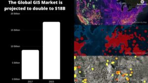
Everyone wants to know where stuff is. Today we all take for granted the use of real time location based services (LBS) which are projected to grow at a CAGR of 26.3%. For instance I can see where the nearest gas station is, where my food delivery is, and where to be rerouted around a traffic accident. The layman calls it Google maps. This is because of the default background map data that is displayed behind the event of interest on their phone. But what lays the ground for these services is all the work done in the lesser known industry called Geographic Information Systems (GIS). It’s a continually growing industry that is projected to double to $18B over a 6 year period. This is producing rising GIS jobs salaries for GIS analyst roles.
The GIS industry connects everything
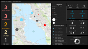
So why should you pay attention to this billion dollar industry? It’s because this technology allows you to analyze and visualize any data that you collect. The seminal idea behind GIS is the connection of a database to a map. The database could be storing data on health, weather, wildfires, endangered species, traffic, crimes, property ownership, smart city design, etc. So it’s very likely that you will collect and store data in any field you are studying. And instead of just viewing it as tabular summaries, you could be viewing it on a digital map. For example, the map will tell you where things are doing really well, average, or in desperate need of action. The most famous recent example is the Johns Hopkins map of COVID-19 infections which has been viewed by 100s of millions of people.
Should I add GIS skills to my portfolio?
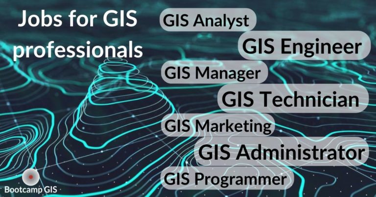
Since 90% of data can be connected to a location, it’s likely that you might want to add this skill to your portfolio. Are you getting a degree in Management of Information Systems? You better enroll in some GIS courses to learn about data and system architecture. Are you unemployed with a degree in biology? You could earn a GIS certificate in 6 months and outcompete a similar biology major without data analysis skills. Once you learn some GIS software and workflows, you can have a degree in anything and become a GIS analyst. GIS exists in government/private agencies at every level and you can see the demand in the GIS Jobs Report, 2023. To win these jobs, most people take classes to upskill their resume and make themselves more marketable.
Which colleges are good for GIS?
If you are searching around for a fulfilling college major, some people get a Bachelor’s in geography. And some go back to school to get a Master’s degree in geography like I did. Look for schools with applied software classes with a blend of IT. But in the tech sector, we find most degrees to be equivalent. It’s really your project experience rather than the name of the school that sets you apart. Therefore, shop around to find an affordable Geography degree. You’ll get a good return on investment if you get involved in multiple projects.
I just want a GIS Certificate
If you want a direct path to building a GIS skillset, then a GIS certificate makes sense. Here are some rankings of Top 10 GIS Certificate Programs. This is a good list as it ranks the curriculums based on their ability to offer practical industry skills. A project based GIS Certificate is your key to demonstrating a technical skill that industry looks for. It’s easy to enroll in the online programs. When you shop, pay attention to: price, time, career services support, and instructor expertise. The best types of courses will give you a blend of GIS/IT/Data/Architecture for reporting and decision making such as:
- Processing imagery from UAVs
- Creating map applications in the AWS cloud
- Scripting in Python to manage data
- Programming a map decision dashboard
Where can I learn more about the GIS industry?
There are webinars by experts that will describe applications or trends such as 5 reasons the GIS industry continues to grow. You can also listen to GIS job recruiters give you their perspective on the job market. Esri is the #1 software vendor and they host the largest GIS conference in the world in San Diego every year. I highly recommend it as this is an awesome place to learn and network.
Conclusion: Use GIS to upskill your career
There is due to be a lot of investment in the infrastructure, planning, and environmental sectors. GIS is a common supporting platform for all three which offers many employment opportunities. Although a college education is great, don’t rely on your degree alone. Be smart about planning your career.
- Pursue an affordable degree
- Upskill with technical courses or certifications
- Network your way to opportunities
Got a degree? No degree? Unemployed? Want to change your job? We are happy to figure out a career path for you.