Smart City Development Utilizing GIS
The development of smart cities
Digital technology is profoundly changing human society. The pace of digital transformation of cities is accelerating. In the future, we may live in a new smart city with full-time public service. Moreover, we may even have efficient and orderly governance, and shared resources that protect the environment. Certainly, GIS technology offers diverse solutions in hundreds of fields covering the gamut of city operation. If you want to join the various high-tech jobs that are being added to the transformation of smart cities, then becoming a GIS developer will be your perfect choice.
Definition of a smart city
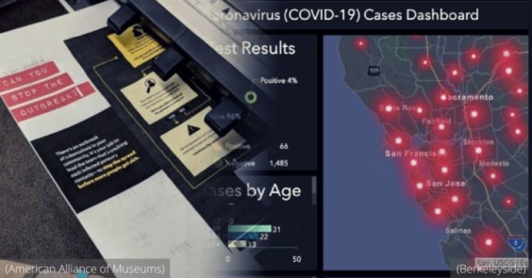
What is a smart city? You may not realize it yet, but your city is definitely becoming a smart city. A smart city is a type of urban development. Especially, It integrates the sensor-based “Internet of Things” to implement real-time management and control of people, devices, and infrastructure within a network. For example, picture a map dashboard that shows where cities lights are turned on and off to conserve electricity and add to public safety. This is a growing space in the public sectors of transportation, energy, commerce, security, and healthcare. This brings a large number of job opportunities for GIS developers.

Smart cities in the U.S.
If you are in the United States, then congratulations. Smart cities are receiving a lot of attention from the government. The reason is it has the potential for significant investment and continued growth in the United States. Why?
First, the United States is the birthplace of the concept of smart cities. In 1960, the Los Angeles government began using aerial photography to collect data and plan city maps and construction, which was highly related to GIS technology.
After that, President Barack Obama announced $160 million in funding in 2015 for a “smart cities” initiative to help improve urban services. The statement said that 54% of the world’s population lives in cities today. Continued population growth and urbanization will create substantial export opportunities for U.S. innovative city-related products and services. Furthermore, the National Science Foundation and National Institute of Standards and Technology provided $45 million in funding to build infrastructure for smart city research.
Other U.S. federal agencies, such as the Department of Transportation, will provide $115 million to explore solutions to urban safety, energy, climate, transportation, and health challenges. Up to now, the United States already has large smart cities, including New York City, San Jose, Los Angeles, Pittsburgh, Boston, Washington DC, San Francisco, and Charlotte. If you want to be involved in building these smart cities, learning GIS will be part of the IoT is an indispensable prerequisite for you.

Smart cities planning and GIS
You may have realized the strong connection between smart cities and GIS technology. Let’s talk about how they are related. The smart city is the information and digital transformation of the city. And, its basic engineering logic is to map the physical and social space of the city to the information space. The information gives freedom to discover problems, analyze them, propose solutions. And then help researchers return to the physical and social space to solve urban issues. And, GIS is the technical science of using locational data to inform decision making.
GIS developers collect locational data from any IoT sensor or smart phone communication. Imagine, traffic light locations having dynamic timing on green light duration depending on current traffic flow. In this case, a stadium event could trigger longer green light durations for traffic coming into specific stadium routes. This would improve gas mileage, reduce pollution, and reduce traffic waits. Utilizing GIS will be the inevitable development route for smart city applications like this.
The future of smart cities
To sum up, the construction of smart cities is still developing and has great potential. And, the jobs offered by future smart cities will require more young high-tech talent with GIS skills. Smart cities may use more emerging technologies in the future, such as artificial intelligence, drones, social media, and remote working. If you are interested in working with future tech applications, then learning GIS and signing up for a GIS certificate online could allow you to become a GIS developer that helps design smart cities.